Feb 27, 2017: Rainy Monday Update

As of 3pm: .16″ at Imperial, and .14″ at NAF El Centro… .12″ at Yuma, .11″ at Blythe, and .02″ at Needles… .15″ at Thermal, .28″ at Palm Springs, .23″ to .25″ at Chino-Ontario… 1.31″!! in San Diego… This rain plume has stalled over the area, across the Imperial Valley and into Arizona.

02272017_regional-southwest-vis-ani12-201702272245-100-100-162220

That moisture plume was expected to move south after dropping some showers…

02272017_2km-nv-vis-ani12-201702272245-100-100-09162220
We expect that rain will be mostly light and continue through midnight (Imperial Valley), when it clears out toward 1am. .08-.16″ of additional rain is expected across the Imperial Valley. It looks like most areas in the Imperial Valley will see storm totals of .22-.30″.

This computer model animation of accumulated precip is for 1pm through 1am.

02272017gfs_ipl_precip

As you can see from the above animation, coastal San Diego is taking the brunt of this storm. A faxed update is also being sent to Valley Weather Service customers. CM

Feb 26, 2017: Precip forecast across SoCal-Arizona, through Tuesday afternoon

The mid Pacific low pressure system we mentioned on the 22nd, is now being pulled in toward mainly Baja, but will also affect southern California and Arizona…

For the Imperial Valley, we are on track to see scattered mostly light showers Monday afternoon through Monday night, 50% chance for .01-.10″, with the south end most susceptible for showers.

hayreportupdate_mondayrain

The GFS Computer Forecast Model displays generally what I have been thinking in terms of precip, .01-.10″ in the valley, scattered showers Monday afternoon through Monday night. Arizona will see more rain thanks to their “upslope” orientation in the southwest flow of winds across the region.

hayreportupdate_rain_monday_02262017

Feb 23, 2017: Rain forecast from the GFS model (23/00Z), for this weekend through Tuesday…

What one computer model (GFS, 23Feb-00Z) is forecasting, precipitation-wise, from Saturday afternoon through Tuesday afternoon. The amount of moisture from the mid-Pacific storm should be limited, so we are only expecting .01-.10″ potential across the valley, and a 20% chance for any one spot being affected. Since Arizona is in an “upslope” position with this incoming system, they will see more precipitation. -CM-

socal_az_precip_satpm_tuepm_00z-20170223

Feb 22, 2017: Storm to move in Sunday and Monday, into Tuesday…

with isolated to scattered showers across the southwest deserts, before an extended period of dry and mostly warm weather in March…

More details to come. If you are a hay report and/ or weather forecast subscriber, register and I will give access to the reports, etc. on this site.

codnexlab-hemi-hemi-ir-ani12-201702220515-100-100-raw

The storm just south of Alaska (see image below), relatively warm and sitting across the mid-Pacific, gets drawn into California by the otherwise dry system that we have been expecting to cause west winds and cooling Sunday and Monday. This dry system is ginning up over northern Alaska right now.

1codnexlab-hemi-n_pacific-ir-ani12-201702220815-100-100-raw

lroutlook

Feb 18, 2017: Longer Range Weather Outlook

Beginning around/ after the 24th of February… It looks like the dominant weather feature over the west coast should be an upper-level ridge of high pressure. This would mean completely dry weather for California and south through Arizona, possibly lasting through the first week to 10 days of March, before we see Pacific storms return to the west coast. We do still need to be watchful for “closed low” pressure systems, since a sharp ridge can tend to allow these to form as we move into spring. These can easily cause rain in the deserts. I will add more detail to this as needed.

Feb 17, 2017: Incoming Rain Event to affect entire southwest US with significant rain…

A strong and unusually moisture-packed low pressure system is bearing down on the area, and rainfall rates of near 6″ in 12 hours has affected some central California Mountains, so some of the rain is intense… This system will sweep across the Desert Southwest and other hay producing/ shipping/ receiving regions now through Sunday…

There will be major delays in production and buying/ selling/ movement of hay, plus some removal of acreage of what otherwise would be premium and supreme test hay.

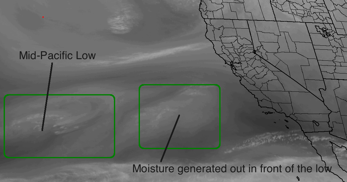
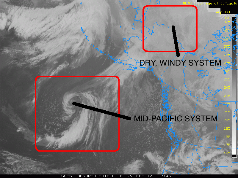
The latest satellite and radar is here:

Infrared satellite with radar/ Visible satellite with radar (please wait for the animation):

codnexlab-regional-southwest-ir-ani12-201702172322-100-100-1620  codnexlab-regional-southwest-vis-ani12-201702172322-100-100-1620

Radar with wind gusts (the white numbers are gusts in MPH: wait for the animation):

codnexlab-1km-s_california-rad-ani12-201702180015-100-100-042220

Chino-Riverside-south to San Diego… 2 to 3+ inches of rain for Chino- Riverside, mainly through tonight, with 1+ inch in San Diego, and 2+ inches inland SD County…

For the Imperial Valley, tonight between 8pm and midnight looks like the best shot at significant rain (.15-.35″ mostly, isolated near 1/2″), then the flow across the mountains becomes westerly into early Saturday morning, at which time moisture will be restricted somewhat by the Laguna Mountain barrier, though showers are still expected, just decreased and less solid in coverage (.01-.10″ additional), as this air mass is too (relatively) warm to be completely “wrung out” as it crosses the mountains. On Saturday we see more spotty and lighter showers in the Imperial Valley, plus some clearing of clouds, though temperatures remain cool, as low pressure starts focusing on Arizona…

For Arizona, Saturday morning through Sunday afternoon is your rain event window, and rain totals are looking significant with some reformation of rain bands and not much to block them from moving in.

Expected rain and time frames for Arizona;

Blythe: .25-.35″/ early Saturday morning, mainly

Yuma: .30-.40″/ Midnight to early Saturday morning, mainly

Gila Bend: .40-.50″/ Saturday morning through Sunday morning, mainly

Central Phoenix: .45-.65″/ Saturday morning through Sunday afternoon, mainly

Tucson: .25-.50″/ Saturday morning through Sunday evening, mainly

Douglas: .45-.80″/ Saturday morning through Sunday evening, mainly

Prescott: .90-1.50″/ Saturday morning through Sunday afternoon, mainly